AAU Herbarium Database |
| New Search Modify Search |
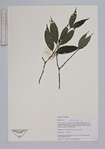
| Collector | Averyanov, L. |
| Number | VH2685 |
| Collected with | N.Q.Binh, P.K.Loc |
| Country | Vietnam |
| Subpart | Lam Dong |
| County | |
| Locality | 31 km to NE from Dalat city, distr. Lac Duong, municipalite Da Chay, vicinities Klong Lanh village. Closed primary broadleaved mt forest on NW macroslope of Bi Dup mt system. |
| Coordinates | 12° 8' N 108° 39' E |
| Minimum elevation (m) | 1850 |
| Maximum elevation (m) | 1950 |
| Start date | 1997/03/15 |
| End date | 1997/03/15 |
| Family | Rubiaceae |
| Identification | Urophyllum Wall. |
| Determined by | |
| Identification qualifier | |
| Field notes | Shrub about 2-2.5 m hg. Ripe fruits orange. Not rare. |
| |
| Display all 41 georeferenced records of Urophyllum Urophyllum |
| New Search Modify Search |