AAU Herbarium Database |
| New Search Modify Search |
| Collector | Averyanov, L. |
| Number | VH1934 |
| Collected with | et al. |
| Country | Vietnam |
| Subpart | Kon Tum |
| County | |
| Locality | S. Vietnam, Prov. Kon Tum, Distr. Dak Gley, about 15-18 km to NW of Dak Gley town, near Mang Khen (Dak Che) village. Primary evergreen mountain very wet forest in deep stream canyon |
| Coordinates | |
| Minimum elevation (m) | 1000 |
| Maximum elevation (m) | 1000 |
| Start date | 1995/11/23 |
| End date | 1995/11/23 |
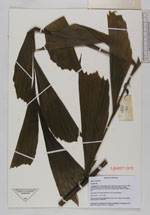
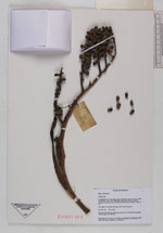
| Family | Arecaceae |
| Identification | Caryota |
| Determined by | |
| Identification qualifier | |
| Field notes | Tree about 3-4 m high with leaves 3.5-4 m lg. Common |
| |
| This record has no coordinates. Display map with the 3 georeferenced records of Caryota in the AAU Herbarium Database. |
| New Search Modify Search |