AAU Herbarium Database |
| New Search Modify Search |
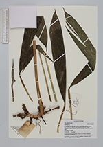
| Collector | Averyanov, L. |
| Number | VH1835 |
| Collected with | N.T.Ban, A.Budantzev, L.Budantzev, N.T.Hiep, D.D.Huyen, P.K.Loc, G.Yakovlev |
| Country | Vietnam |
| Subpart | Kon Tum |
| County | |
| Locality | Distr. Dak Gley, about 10 km to N of Dak Gley town, between Dak Nen and Mang Khen (Dak Che) villages. Secondary evergreen mountain forest rich in primary elements. |
| Coordinates | |
| Minimum elevation (m) | 800 |
| Maximum elevation (m) | 900 |
| Start date | 1995/11/19 |
| End date | 1995/11/19 |
| Family | Zingiberaceae |
| Identification | Zingiberaceae |
| Determined by | |
| Identification qualifier | |
| Field notes | Herb about 1.5 m high. |
| |
| This record has no coordinates. Display map with the 15 georeferenced records of Zingiberaceae in the AAU Herbarium Database. |
| New Search Modify Search |