AAU Herbarium Database |
| New Search Modify Search |
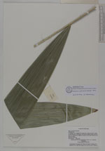
| Collector | Averyanov, L. |
| Number | VH1434 |
| Collected with | et al. |
| Country | Vietnam |
| Subpart | Khanh Hoa |
| County | |
| Locality | S. Vietnam, Prov. Khanh Hoa. Open dry evergreen forest on cliffs, on NE slope of Bi Dup mountain system, near 5-6 km to W of Khanh Le village on Lieng Ly river (near 15 km to W of Cau Ba village) |
| Coordinates | |
| Minimum elevation (m) | 200 |
| Maximum elevation (m) | 300 |
| Start date | 1995/04/23 |
| End date | 1995/04/23 |
| Family | Arecaceae |
| Identification | Calamus platyacanthoides Merr. |
| Determined by | A. Henderson |
| Identification qualifier | |
| Field notes | Wine up to 20 m lg. |
| |
| This record has no coordinates. Display map with the 4 georeferenced records of Calamus platyacanthoides in the AAU Herbarium Database. |
| New Search Modify Search |