AAU Herbarium Database |
| New Search Modify Search |
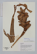
| Collector | Averyanov, L. |
| Number | CBL477 |
| Collected with | P.K.Loc, N.X.Tam |
| Country | Vietnam |
| Subpart | Cao Bang |
| County | |
| Locality | Distr. Bao Lac, municipality Dinh Phung, About 5 km to NW from Yen Lac village, about 50 km to NWW from Cao Bang town. Old secondary closed broadleaved wet cloud forest on steep slopes and cliffs along top of Nam Linh limestone ridge. |
| Coordinates | 22° 44' N 105° 50' E |
| Minimum elevation (m) | 1500 |
| Maximum elevation (m) | 1580 |
| Start date | 1998/11/19 |
| End date | 1998/11/19 |
| Family | Zingiberaceae |
| Identification | Hedychium |
| Determined by | K.Larsen |
| Identification qualifier | |
| Field notes | Forb up to 2 m hg. Ripe fruits yellow inside, seeds brightly red. Common. |
| |
 Other records of Hedychium Other records of HedychiumThe map displays only records from the Aarhus Herbarium Database. The records may not represent the full distribution of Hedychium |
| New Search Modify Search |