AAU Herbarium Database |
| New Search Modify Search |
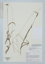
| Collector | Averyanov, L. |
| Number | CBL1157 |
| Collected with | N.Q. Binh, N.T. Loc, N.X. Tam |
| Country | Vietnam |
| Subpart | Cao Bang |
| County | |
| Locality | N. Vietnam. Distr. Tra Linh, municipality Luu Ngoc, vicinities of Lung Mu village, about 14 km from Cao Bang town to the N. Secundary shrubs and grasslands on alluvial valley between remnant limestone ridges and mesas. |
| Coordinates | 22° 47' N 106° 18' E |
| Minimum elevation (m) | 600 |
| Maximum elevation (m) | 650 |
| Start date | 1998/12/13 |
| End date | 1998/12/13 |
| Family | Poaceae |
| Identification | Digitaria setigera Roth |
| Determined by | B. Boonsuk |
| Identification qualifier | |
| Field notes | Grass up to 0.6 m hg. Very common. Grasslands codominante. |
| |
| Display all 35 georeferenced records of Digitaria Digitaria setigera |
| New Search Modify Search |