AAU Herbarium Database |
| New Search Modify Search |
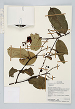
| Collector | Romoleroux, K. |
| Number | 3157 |
| Collected with | M.Zambrano, H.Mogollón |
| Country | Ecuador |
| Subpart | Francisco de Orellana |
| County | |
| Locality | ESTACIÓN CIÉNTIFICA YASUNÍ. Río tiputini, al NO de la confluencia con el Río tivacuno; 6 km al E de la carretera Maxus, km 44, desvío hacia el Pozo Tivacuno. Parcela de 50 Ha. Árbol con placa #105945. Terra firm; lomas de 30-50 m, de arcilla rojiza. |
| Coordinates | 0° 41' S 76° 24' W |
| Minimum elevation (m) | 200 |
| Maximum elevation (m) | 300 |
| Start date | 1988/10/05 |
| End date | 1988/10/05 |
| Family | Lecythidaceae |
| Identification | Eschweilera Mart. ex DC. |
| Determined by | |
| Identification qualifier | |
| Field notes | Árbol de 40 m. Flores con pétalos blancos y estambres amarillos. |
| |
 Other records of Eschweilera Other records of EschweileraThe map displays only records from the Aarhus Herbarium Database. The records may not represent the full distribution of Eschweilera |
| New Search Modify Search |