| Collector | Vormisto, J. |
| Number | 677 |
| Collected with | A. Byg |
| Country | Ecuador |
| Subpart | ZAMORA-CHINCHIPE/NANGARITZA |
| County | |
| Locality | Río Nangaritza. Ca. 1,3 km to SW from the village of Miazi. Premontane, unflooded, old-growth rain forest on clay soil. |
| Coordinates | 4° 16' S 78° 37' W |
| Minimum elevation (m) | 880 |
| Maximum elevation (m) | 990 |
| Start date | 2002/12/03 |
| End date | 2002/12/03 |
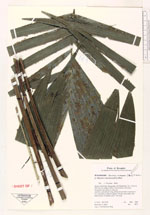
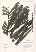
| Family | Arecaceae |
| Identification | Bactris macana (Mart.)Pittier |
| Determined by | J. Vormisto 2003 |
| Identification qualifier | |
| Field notes | Juvenile. Leaf 265 cm long, pinnae 24 per side, in groups of 4-5, spreading in different planes. Pinnae hairy below, few black spines on petiole, up to 1 cm long. |
|
 Other records of Bactris macana