| Collector | Vormisto, J. |
| Number | 666 |
| Collected with | A. Byg |
| Country | Ecuador |
| Subpart | ZAMORA-CHINCHIPE/NANGARITZA |
| County | |
| Locality | Río Nangaritza. Ca. 2 km to S from the village of Las Orquideas. Premontane, unflooded, old-growth, stunted rain forest with canopy between 10 and 15 m height. Subcanopy and understory dense with shrubs and lianas. Ground covered by a thick layer of organic material. |
| Coordinates | 4° 12' S 78° 39' W |
| Minimum elevation (m) | 940 |
| Maximum elevation (m) | 1060 |
| Start date | 2002/11/20 |
| End date | 2002/11/20 |
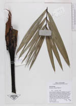
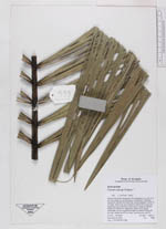
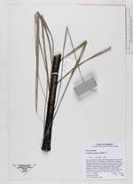
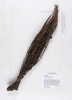
| Family | Arecaceae |
| Identification | Euterpe catinga var. roraimae (Dammer)A.J.Hend. & Galeano |
| Determined by | J. Vormisto 2003 |
| Identification qualifier | |
| Field notes | Blade 205, petiole 18 cm, green crownshaft 112 cm long. Black scales on petiole. Pinnae 46 per side, middle ones 50 cm long. Infructescence with 25 branches, peduncle 7 cm, rachillae 32 cm, fruits green. |
|
 Other records of Euterpe catinga var. roraimae