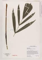
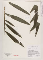
| Collector | Vormisto, J. |
| Number | 642 |
| Collected with | A. Byg |
| Country | Ecuador |
| Subpart | ZAMORA-CHINCHIPE/NANGARITZA |
| County | |
| Locality | Río Nangaritza. Ca. 200 m to SE from the village of Shaimi. Premontane, unflooded, old-growth, stunted forest with canopy between 10 and 15 m height. Subcanopy and understory dense with shrubs and lianas. Ground covered by a thick layer of organic material. |
| Coordinates | 4° 18' S 78° 39' W |
| Minimum elevation (m) | 900 |
| Maximum elevation (m) | 930 |
| Start date | 2002/11/10 |
| End date | 2002/11/10 |
| Family | Arecaceae |
| Identification | Wettinia longipetala A.H. Gentry |
| Determined by | J. Vormisto 2003 |
| Identification qualifier | |
| Field notes | 2 m tall juvenile. 11 narrow pinnae per side, apical pinnae more narrow than juveniles of W. maynesis. |
|
 Other records of Wettinia longipetala