AAU Herbarium Database |
| New Search Modify Search |
| Collector | Vormisto, J. |
| Number | 557 |
| Collected with | S. Wendelboe, H. Balslev |
| Country | Peru |
| Subpart | |
| County | |
| Locality | Loreto, Maynas. East of Rio Napo confluence (about 20 min in boat), close to the village of Roca Eterna. Old-growth, non-inundated lowland forest on flat bottomland |
| Coordinates | 3° 26' S 72° 30' W |
| Minimum elevation (m) | 100 |
| Maximum elevation (m) | 150 |
| Start date | 2002/06/26 |
| End date | 2002/06/26 |
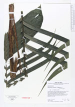
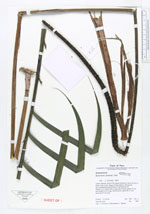
| Family | Arecaceae |
| Identification | Geonoma camana Trail |
| Determined by | Vormisto, J. |
| Identification qualifier | |
| Field notes | Height, 2,5 m. Blade 128 cm long, 55 cm wide, petiole 47 cm and sheath 24 cm long. Inflorescence; spike 38 cm and peduncle 57 cm long |
| |
| Display all 57 georeferenced records of Geonoma Geonoma camana |
| New Search Modify Search |