AAU Herbarium Database |
| New Search Modify Search |
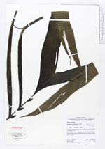
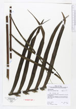
| Collector | Vormisto, J. |
| Number | 349 |
| Collected with | Vargas, V. |
| Country | Peru |
| Subpart | Loreto |
| County | |
| Locality | Maynas. Río Yaguasyacu. Ca. 3,5 km to N-NW of the village Puerto Izango. Unflooded primary rain forest on loamy soil, on a hill. |
| Coordinates | 3° 16' S 72° 0' W |
| Minimum elevation (m) | 100 |
| Maximum elevation (m) | 150 |
| Start date | 1997/05/16 |
| End date | 1997/05/16 |
| Family | Arecaceae |
| Identification | Geonoma camana Trail |
| Determined by | Vormisto, J. |
| Identification qualifier | |
| Field notes | Pinnae 33 per side. Inflorescence; peduncle 35 cm, rachis 26 cm. Height 250 m. |
| |
| Display all 57 georeferenced records of Geonoma Geonoma camana |
| New Search Modify Search |