| Collector | Vormisto, J. |
| Number | 118 |
| Collected with | Criollo, G. |
| Country | Peru |
| Subpart | Loreto |
| County | |
| Locality | Maynas. Río Nanay. Ca. 5.5 km to NW of the village of Tarapoto. Unflooded primary rain forest on clay soil, on a hill. |
| Coordinates | 3° 47' S 73° 27' W |
| Minimum elevation (m) | 100 |
| Maximum elevation (m) | 150 |
| Start date | 1996/02/20 |
| End date | 1996/02/20 |
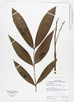
| Family | Arecaceae |
| Identification | Desmoncus polyacanthos Mart. |
| Determined by | Vormisto, J. |
| Identification qualifier | |
| Field notes | Needle-like spines. Leaflets 5 - 7 cm wide. |
|