AAU Herbarium Database |
| New Search Modify Search |
| Collector | Burley, J.S. |
| Number | 1086 |
| Collected with | Tukirin et al. |
| Country | Indonesia |
| Subpart | Sumatra |
| County | |
| Locality | Tigapulu Mts., Riau Province, 5 km W of Talanglakat on Rengat-Jambi Road, Bukit Karampal area. Open secondary forest, along logging roadsides, common. |
| Coordinates | 0° 46' S 102° 32' E |
| Minimum elevation (m) | 100 |
| Maximum elevation (m) | 100 |
| Start date | 1988/11/04 |
| End date | 1988/11/04 |
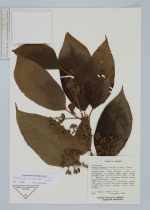
| Family | Lamiaceae |
| Identification | Callicarpa pentandra Roxb. |
| Determined by | C. Leeratiwong |
| Identification qualifier | |
| Field notes | Small tree c. 6 m tall; 10 cm dia.; calyx tube green; corolla tube white; petal lobes, stigma and anther purple. Local name: Situhah. |
| |
 Other records of Callicarpa pentandra Other records of Callicarpa pentandraThe map displays only records from the Aarhus Herbarium Database. The records may not represent the full distribution of Callicarpa pentandra |
| New Search Modify Search |