| Collector | Ruiz, J. |
| Number | 5202 |
| Collected with | L.P. Kvist & L. Freitas A. |
| Country | Peru |
| Subpart | Loreto |
| County | |
| Locality | Along the lower Ucayali river, approx. 7 km southwest of the Jenaro Herrera village, "Zona de Lobillo". From plot 5 (of nine 100 x 100 meters large permanent plots). Plot flooded up to several meters and often for more than a half year annually (tahuampa). Mostly flooded by black water from local upland streams, but occasionally also by white water from the Ucayali river |
| Coordinates | 4° 59' S 73° 44' W |
| Minimum elevation (m) | 120 |
| Maximum elevation (m) | 120 |
| Start date | 1993/09/01 |
| End date | 1994/02/12 |
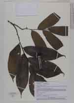
| Family | Annonaceae |
| Identification | Guatteria hirsuta Ruiz & Pav. |
| Determined by | P.J.M.Maas & L.Y.Th.Westra |
| Identification qualifier | |
| Field notes | Tree 10 m tall, 106 mm dbh |
|
 Other records of Guatteria hirsuta