AAU Herbarium Database |
| New Search Modify Search |
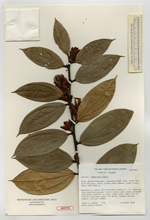
| Type of: | Orthaea fimbriata Luteyn |
| Collector | Luteyn, J.L. |
| Number | 5794 |
| Collected with | M. Lebrón-Luteyn |
| Country | Ecuador |
| Subpart | Morona-Santiago |
| County | |
| Locality | Gualaceo-Limon road, 53-64 kms E of Gualaceo. Steep slopes with remnant cloud forest |
| Coordinates | |
| Minimum elevation (m) | 1870 |
| Maximum elevation (m) | 2150 |
| Start date | 1978/04/19 |
| End date | 1978/04/19 |
| Family | Ericaceae |
| Identification | Orthaea fimbriata Luteyn |
| Determined by | |
| Identification qualifier | |
| Field notes | Terrestrial shrub with branches arching to 2 m. Rhachis pale yellowish-green; floral bracts pale green suffused with pink; pedicels & calyx light pink; lower 3/4 of corolla rose-red, upper 1/4 white; fruits turning purple. Locally common. |
| |
| This record has no coordinates. Display map with the 5 georeferenced records of Orthaea fimbriata in the AAU Herbarium Database. |
| New Search Modify Search |