| Collector | Luteyn, J.L. |
| Number | 15385 |
| Collected with | Hugo Mogollon |
| Country | Ecuador |
| Subpart | Morona-Santiago |
| County | |
| Locality | Limon-Gualaquiza road, 15.3 km S of Plan de Milagro (military post). Open, heavily disturbed roadside slopes with remnant patches of forest |
| Coordinates | 3° 3' S 78° 30' W |
| Minimum elevation (m) | 1000 |
| Maximum elevation (m) | 1000 |
| Start date | 1998/11/19 |
| End date | 1998/11/19 |
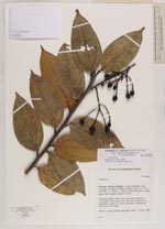
| Family | Ericaceae |
| Identification | Psammisia coarctata (Ruiz & Pav.)A.C.Sm. |
| Determined by | James L. Luteyn |
| Identification qualifier | aff. |
| Field notes | Terrestrial shrub, along steep open slope, branches to 2.5 m long. Pedicels and calyx dark red. Corolla twice constricted, bright red at base and white in constricted distal part. Fruit green |
|
 Other records of Psammisia coarctata