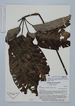
| Collector | Korning, J. |
| Number | 47764 |
| Collected with | Thomsen, K. |
| Country | Ecuador |
| Subpart | NAPO |
| County | |
| Locality | Añangu, NW corner of the "Parque Nacional Yasuní". Primary terra firme forest on permanent study plot S of SEF point 51, on the highest plateau in the area. KTH numbers refers to the tagging of all plot trees with DBH above 10 cm. |
| Coordinates | 0° 33' S 76° 22' W |
| Minimum elevation (m) | 355 |
| Maximum elevation (m) | 365 |
| Start date | 1986/02/01 |
| End date | 1986/02/15 |
| Family | Araliaceae |
| Identification | Didymopanax morototoni (Aubl.) Dcne. & Planch. |
| Determined by | Dr. Pete Lowry |
| Identification qualifier | |
| Field notes | Tree 29.6 m X 46.3 cm. KTH tree no. 596 Bark light brown with transversal ridges and depres- sions and some lenticells. Yellow, coagulating latex. Local name "Capayo casco muyo" ("Lenteja muyo"). Name refering to lentil-shape of fruits. Ethnobotanical information by Victor Rivadeneira. |
|
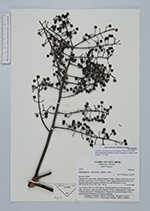
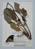
 Other records of Didymopanax morototoni