AAU Herbarium Database |
| New Search Modify Search |
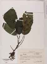
| Collector | Jaramillo, J. |
| Number | 6464 |
| Collected with | |
| Country | Ecuador |
| Subpart | Pichincha |
| County | |
| Locality | Reserva Forestal ENDESA. Rio Silanche: “Corporacion Forestal Juan Manuel Durini”, km 113 de la carretera Quito-Pto. Quito, faldas iccidentales, a 10 km al Norte de la carretera principal |
| Coordinates | 0° 5' N 79° 2' W |
| Minimum elevation (m) | 650 |
| Maximum elevation (m) | 700 |
| Start date | 1984/02/26 |
| End date | 1984/02/26 |
| Family | Urticaceae |
| Identification | Urera Gaudich. |
| Determined by | M.Weigend |
| Identification qualifier | sp. |
| Field notes | Bosque Primario de la reserva |
| |
 Other records of Urera Other records of UreraThe map displays only records from the Aarhus Herbarium Database. The records may not represent the full distribution of Urera |
| New Search Modify Search |