AAU Herbarium Database |
| New Search Modify Search |
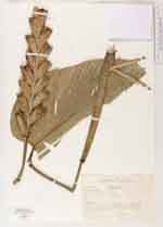
| Collector | Jaramillo, J. |
| Number | 13210 |
| Collected with | E.Grijalva |
| Country | Ecuador |
| Subpart | Sucumbios |
| County | |
| Locality | Colecciones en ael sector Nor Oeste de la Cascada San Rafael. Area barrancosa, pendiente muy accidentada, cubierta por heleechos de las familias; Blechnaceae, Gleicheniaceae, Pteridaceae y arbustos; Gonzalagunia, Baccharis, Koehleria, etc. |
| Coordinates | 0° 7' 24'' S 77° 10' 54'' W |
| Minimum elevation (m) | 1300 |
| Maximum elevation (m) | 1300 |
| Start date | 1990/10/11 |
| End date | 1990/10/11 |
| Family | Marantaceae |
| Identification | Calathea |
| Determined by | |
| Identification qualifier | |
| Field notes | Hierba de 2 m, bracteas verdes y rojas, frutos rojos |
| |
 Other records of Calathea Other records of CalatheaThe map displays only records from the Aarhus Herbarium Database. The records may not represent the full distribution of Calathea |
| New Search Modify Search |