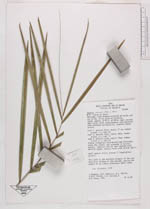
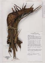
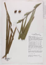
| Collector | Jangoux, J. |
| Number | 1772 |
| Collected with | et al. |
| Country | Brazil |
| Subpart | Amazonas |
| County | |
| Locality | Maranhão, road between Estreito de Goiás and Carolina, 23 km south of Estreito Open cerrado. Small palm, with subterraneous root-emitting stem extended horizontally; stemless above ground |
| Coordinates | 6° 45' S 47° 20' W |
| Minimum elevation (m) | 0 |
| Maximum elevation (m) | 0 |
| Start date | 1981/12/01 |
| End date | 1981/12/01 |
| Family | Arecaceae |
| Identification | Syagrus petraea (Mart.)Becc. |
| Determined by | |
| Identification qualifier | |
| Field notes | Leaf 1: petiole 25cm; rachis 77 cm; number pinnae (1 s ide) 24Leaf 2: petiole 16cm; rachis 49cm; number pinnae (1 s ide) 17Leaf 3: petiole 23cm; rachis 75cm; number pinnae (1 s ide) 29Pinnae irregulary distributed and clustered along the rachis, and oriented in various planes. Abaxial side of leaf covered with whitish powder. Mature fruit with active smell; small mature fruits present 3 longitudinal grooves. This palm is the dominant element in the subarbustive stratum of the cerrado, having the aspect of an almost continuous grass cover N.V. "Tucum de indio" |
|
 Other records of Syagrus petraea