| Collector | Gobilik, J. |
| Number | 840 |
| Collected with | |
| Country | Malaysia |
| Subpart | Sabah |
| County | |
| Locality | Tambunan District, Trus Madi Range. Roadside, old logging road to the trail to Mt. Trus Madi summit. Secondary forest, wet shady area, sandy rocky soil. |
| Coordinates | 5° 34.460999999999999' N 116° 29.312999999999999' E |
| Minimum elevation (m) | 1447 |
| Maximum elevation (m) | 1447 |
| Start date | 2001/10/24 |
| End date | 2001/10/24 |
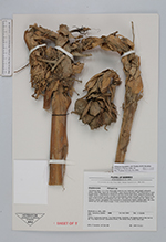
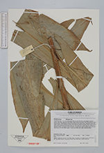
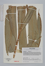
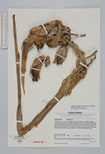
| Family | Zingiberaceae |
| Identification | Etlingera baculutea A.D.Poulsen & H.Ibrahim |
| Determined by | A.D.Poulsen |
| Identification qualifier | |
| Field notes | Terrestial herb. 1.5-1.7 m. Base pale white to very mild red. Leaf sheath yellowish green, reticulate; ligule dry and brittle; upper leaves dull green with mild purple or dark purple below. Inflorescence arinsing at the base of the leafy shoot; peduncle bracts pale white; sterile bracts purple red with some greenish shade especially when expose to the light; fertile bracts and bracteole mild red; calyx dark red, corolla tube red, petals red; labellum yellow, elongated, the truncated or occasionally slightly bilobed apex red, side/lateral lips red with frilled margin. Fruits red at the top to pale yellowish below. |
|
 Other records of Etlingera baculutea