AAU Herbarium Database |
| New Search Modify Search |
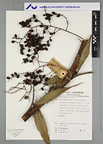
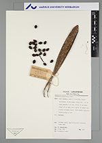
| Collector | Wessels Boer, J.G. |
| Number | 1037 |
| Collected with | |
| Country | Suriname |
| Subpart | |
| County | |
| Locality | Oelemari river, bank 20 km above airstrip; loamy sand |
| Coordinates | |
| Minimum elevation (m) | 0 |
| Maximum elevation (m) | 0 |
| Start date | 1963/03/19 |
| End date | 1963/03/19 |
| Family | Arecaceae |
| Identification | Desmoncus polyacanthos Mart. |
| Determined by | W. Boer |
| Identification qualifier | |
| Field notes | High climbing liana to 10 m long; leaves distichous, in one plane; sheat 8,5-15 cm long, petiole 2 cm long; rachis 59 cm long, flagel 42 cm long; with 9 pairs of pinnae and 6 pairs of hooks (unci); fruits green, maturing yellow, orange to red. N.v. bambamaka |
| |
| This record has no coordinates. Display map with the 53 georeferenced records of Desmoncus polyacanthos in the AAU Herbarium Database. |
| New Search Modify Search |