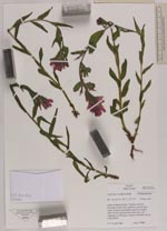
| Collector | Smith, J.F. |
| Number | 7466 |
| Collected with | |
| Country | USA |
| Subpart | Idaho |
| County | |
| Locality | North of Hazard Lake, Clayburn Trail to Partridge Creek Trail, partially burned open slope, melting snowbanks present at higher ends of trail, grazed |
| Coordinates | 45° 16' 6'' N 116° 11' 10'' W |
| Minimum elevation (m) | 7702 |
| Maximum elevation (m) | 7702 |
| Start date | 2008/07/09 |
| End date | 2008/07/09 |
| Family | Scrophulariaceae |
| Identification | Castilleja rhexiifolia Rydb. |
| Determined by | |
| Identification qualifier | |
| Field notes | Bracts and calyx red-magenta, corolla green edged with pink, keyed with FPNW |
|