AAU Herbarium Database |
| New Search Modify Search |
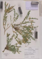
| Collector | Smith, J.F. |
| Number | 7200 |
| Collected with | |
| Country | USA |
| Subpart | Idaho |
| County | |
| Locality | Bruneau River overlook, rim and side canyon |
| Coordinates | 42° 41' 17'' N 115° 40' 27'' W |
| Minimum elevation (m) | 7200 |
| Maximum elevation (m) | 7200 |
| Start date | 2008/05/23 |
| End date | 2008/05/23 |
| Family | Fabaceae |
| Identification | Astragalus beckwithii var. weiserensis M.E.Jones |
| Determined by | |
| Identification qualifier | |
| Field notes | Prostrate, pods mopttled with red, Keyed from IMF |
| |
 Other records of Astragalus beckwithii var. weiserensis Other records of Astragalus beckwithii var. weiserensisThe map displays only records from the Aarhus Herbarium Database. The records may not represent the full distribution of Astragalus beckwithii var. weiserensis |
| New Search Modify Search |