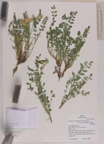
| Collector | Smith, J.F. |
| Number | 6053 |
| Collected with | |
| Country | USA |
| Subpart | Idaho |
| County | |
| Locality | T14S R22E s 19nw. Hills above and west of Goose Creek Reservoir rocky open slope |
| Coordinates | 42° 11' 41'' N 113° 55' 44'' W |
| Minimum elevation (m) | 5007 |
| Maximum elevation (m) | 5007 |
| Start date | 2006/05/25 |
| End date | 2006/05/25 |
| Family | Fabaceae |
| Identification | Astragalus beckwithii var. weiserensis M.E.Jones |
| Determined by | |
| Identification qualifier | |
| Field notes | Stems mostly prostrate, corolla very pale yellow, fruits green with red-purple spots |
|
 Other records of Astragalus beckwithii var. Weiserensis