AAU Herbarium Database |
| New Search Modify Search |
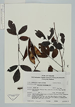
| Collector | Maxwell, J.F. |
| Number | 92-673 |
| Collected with | |
| Country | Thailand |
| Subpart | Chiang Mai |
| County | |
| Locality | Doi Sutep-Pui National Park, south side, near Ban Bong, Ban Bong Subdistrict. |
| Coordinates | |
| Minimum elevation (m) | 400 |
| Maximum elevation (m) | 0 |
| Start date | 1992/11/05 |
| End date | 0/00/00 |
| Family | Fabaceae |
| Identification | Millettia brandisiana Kurz |
| Determined by | |
| Identification qualifier | |
| Field notes | Open to partly shaded area in dsturbed deciduous forest; fire-prone area; shale bedrock. Deciduous tree 8 m, dbh 8 cm; bark thin, slightly cracked, grey; infructescence axes dull green; pods light greenish; leaflets green above, dull light green underneath. |
| |
| This record has no coordinates. Display map with the 8 georeferenced records of Millettia brandisiana in the AAU Herbarium Database. |
| New Search Modify Search |