AAU Herbarium Database |
| New Search Modify Search |
| Collector | Maxwell, J.F. |
| Number | 92-461 |
| Collected with | |
| Country | Thailand |
| Subpart | Lamphun |
| County | |
| Locality | Mae Tah District. Doi Kuhn Dahn National Park, west side, near Ben Kukrit. Mostly shaded area, margins of the mixed evergreen + deciduous forest, granite bedrock. |
| Coordinates | |
| Minimum elevation (m) | 1025 |
| Maximum elevation (m) | 1025 |
| Start date | 1992/08/22 |
| End date | 1992/08/22 |
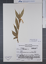
| Family | Zingiberaceae |
| Identification | Globba garrettii Kerr |
| Determined by | S. Sangvirotjanapat & M.F. Newman |
| Identification qualifier | |
| Field notes | Stems dark maroon, inflorescence nodding, axes & calyx green; bracts reflexed, whitish-pale light greenish on both sides; corolla, filament dull orange, lip orange with a red-brown spot medially; anther orange; blades dull dark green above, pale light underneath. |
| |
| This record has no coordinates. Display map with the 11 georeferenced records of Globba garrettii in the AAU Herbarium Database. |
| New Search Modify Search |