AAU Herbarium Database |
| New Search Modify Search |
| Collector | Maxwell, J.F. |
| Number | 91-984 |
| Collected with | |
| Country | Thailand |
| Subpart | Prae |
| County | |
| Locality | District, Song. Mae Yom National Park, west side of Yom River in the Huay Sook area; Saiab Subdistrict. Habitat, partly open, fire-prone thicket in disturbed deciduous, mostly teak & bamboo, forest; limestone bedrock |
| Coordinates | |
| Minimum elevation (m) | 225 |
| Maximum elevation (m) | 225 |
| Start date | 1991/11/07 |
| End date | 1991/11/07 |
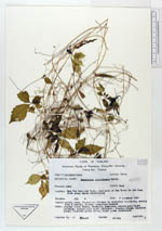
| Family | Cucurbitaceae |
| Identification | Gomphogyne cissiformis Griff. |
| Determined by | |
| Identification qualifier | |
| Field notes | Slender vine; stems, tendrils, pedicels, sepals pale light greenish; petals pale light yellowish; stamens cream; capsules green; leaflets green above, light green underneath |
| |
| This record has no coordinates. Display map with the 1 georeferenced records of Gomphogyne cissiformis in the AAU Herbarium Database. |
| New Search Modify Search |