AAU Herbarium Database |
| New Search Modify Search |
| Collector | Maxwell, J.F. |
| Number | 91-854 |
| Collected with | |
| Country | Thailand |
| Subpart | Northern |
| County | |
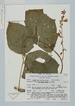
| Locality | Phrae. Mae Yom National Park, east side of Mae Yom (River) across from Jahm Kong camp; Dow Boon Subdistrict. Open to partly shaded, disturbed places near a village, deciduous forest; shale bedrock |
| Coordinates | |
| Minimum elevation (m) | 225 |
| Maximum elevation (m) | 225 |
| Start date | 1991/10/09 |
| End date | 1991/10/09 |
| Family | Fabaceae |
| Identification | Pachyrhizus erosus (L.)Urb. |
| Determined by | Ashley N. Egan (US) 2016 |
| Identification qualifier | |
| Field notes | Vine; Stem; petioles, raceme axes green; pedicels & calyx dull light greenish; standard outside blue, inside deep blue, wings deep blue; standard with a yellow-green blot at base inside, immature pode light green; leaflets dark green above, green below |
| |
| This record has no coordinates. Display map with the 6 georeferenced records of Pachyrhizus erosus in the AAU Herbarium Database. |
| New Search Modify Search |