AAU Herbarium Database |
| New Search Modify Search |
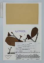
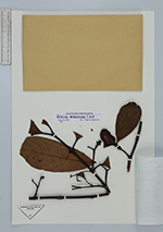
| Collector | Maxwell, J.F. |
| Number | 91-361 |
| Collected with | |
| Country | Thailand |
| Subpart | Chiang Mai |
| County | |
| Locality | Muang District. Doi Sutep-Pui National Park, east side, upper Mohntatahn catchment. Shaded understorey of the primary evergreen forest, granite bedrock. |
| Coordinates | |
| Minimum elevation (m) | 1300 |
| Maximum elevation (m) | 1300 |
| Start date | 1991/04/19 |
| End date | 1991/04/19 |
| Family | Clusiaceae |
| Identification | Garcinia mckeaniana Craib |
| Determined by | C. Ngernsaengsaruay |
| Identification qualifier | |
| Field notes | Tree 17 m, dbh 23 cm; bark thin, smooth, grey; branching monopodial; latex yellow; pedicels, sepals green; fruits light green and turning green with darker green lines from tip to base, ripening light yellowish inside and outside, to 5.5 x 4.5 cm, soft; aril light yellow; blades dark green above, green underneath. |
| |
| This record has no coordinates. Display map with the 1 georeferenced records of Garcinia mckeaniana in the AAU Herbarium Database. |
| New Search Modify Search |