AAU Herbarium Database |
| New Search Modify Search |
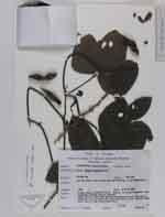
| Collector | Maxwell, J.F. |
| Number | 91-239 |
| Collected with | |
| Country | Thailand |
| Subpart | Chiang Mai |
| County | |
| Locality | Mae Asoi Ridge, west slope, Ben Bah Sohn Mai, Tapah Subdistrict. Partly open, disturbed (fire) area in the mixed evergreen hardwood/pine forest; granite bedrock |
| Coordinates | |
| Minimum elevation (m) | 1550 |
| Maximum elevation (m) | 1550 |
| Start date | 1991/03/09 |
| End date | 1991/03/09 |
| Family | Fabaceae |
| Identification | Mucuna bracteata DC. |
| Determined by | Ch.W.Pen |
| Identification qualifier | |
| Field notes | Vine; stems & leaf axes green; infructescence axes dull light greenish; pods golden-brown with irritating hairs; leaflets dark green above, light green underneath |
| |
| This record has no coordinates. Display map with the 1 georeferenced records of Mucuna bracteata in the AAU Herbarium Database. |
| New Search Modify Search |