AAU Herbarium Database |
| New Search Modify Search |
| Collector | Maxwell, J.F. |
| Number | 91-1058 |
| Collected with | |
| Country | Thailand |
| Subpart | Prae |
| County | |
| Locality | Mae Yom National Park, north part, west side of the Yom River in the Mae Den area; Sahiab Subdistrict. Partly shaded, distrubed thickets near the Yom River in clearings in the decidous teak & bamboo forest; shale bedrock. |
| Coordinates | |
| Minimum elevation (m) | 225 |
| Maximum elevation (m) | 225 |
| Start date | 1991/11/14 |
| End date | 1991/11/14 |
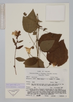
| Family | Malvaceae |
| Identification | Urena repanda Roxb. ex Sm. |
| Determined by | Leena Phuphathanaphong |
| Identification qualifier | |
| Field notes | Shrub to 1.5 m tall; stems, petioles, inflorescence axes green; epicalyx green with dark reddish lobes; calyx dull reddish; entire corolla, filaments, stigmas, styles pink; anthers darker pink; blades dull dark green above, light green underneath. |
| |
| This record has no coordinates. Display map with the 1 georeferenced records of Urena repanda in the AAU Herbarium Database. |
| New Search Modify Search |