AAU Herbarium Database |
| New Search Modify Search |
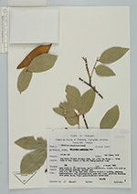
| Collector | Maxwell, J.F. |
| Number | 90-839 |
| Collected with | |
| Country | Thailand |
| Subpart | Chiang Mai |
| County | |
| Locality | Awp Luang ( Gorge) National park, along Mae Jam River, c. 14 km west of Hod; Summit of Koi Pah Chang (Granite berock) |
| Coordinates | |
| Minimum elevation (m) | 450 |
| Maximum elevation (m) | 0 |
| Start date | 1990/08/04 |
| End date | 0/00/00 |
| Family | Fabaceae |
| Identification | Millettia latifolia Dunn |
| Determined by | |
| Identification qualifier | |
| Field notes | Open places in the deciduous, mostly dipterocarp, forest, thin soil on solid granite bedrock; escosed area tree 8 m, dbh 6 cm; bark thin, roughly cracked & flacking, greyish; dark green above, light greenish-greyish underneath. |
| |
| This record has no coordinates. Display map with the 1 georeferenced records of Millettia latifolia in the AAU Herbarium Database. |
| New Search Modify Search |