AAU Herbarium Database |
| New Search Modify Search |
| Collector | Maxwell, J.F. |
| Number | 90-833 |
| Collected with | |
| Country | Thailand |
| Subpart | Chiang Mai |
| County | |
| Locality | Awp Luang ( Gorge) National park, c. 14 km west of Hod along Mae Jam River |
| Coordinates | |
| Minimum elevation (m) | 425 |
| Maximum elevation (m) | 0 |
| Start date | 1990/08/04 |
| End date | 0/00/00 |
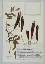
| Family | Fabaceae |
| Identification | Millettia brandisiana Kurz |
| Determined by | |
| Identification qualifier | |
| Field notes | Open place, fire-prone area in the deciduous, mostly dipterocarp, forest; granite bedrock. Deciduous tree 6 m, dbh 8 cm; bark thin, smooth and with minute pustular lentcels, grey; infructescence pendulous, axes dull greenish-brownish; pods yellow green; leaflets dark green above, light green underneath. |
| |
| This record has no coordinates. Display map with the 8 georeferenced records of Millettia brandisiana in the AAU Herbarium Database. |
| New Search Modify Search |