AAU Herbarium Database |
| New Search Modify Search |
| Collector | Maxwell, J.F. |
| Number | 89-37 |
| Collected with | |
| Country | Thailand |
| Subpart | Chiang Mai |
| County | |
| Locality | Doi Sutep, east side, CMU Obersatory area. Shaded soil embankment along a stream in the mixed evergreen/deciduous forest with some bamboo; granite bedrock. |
| Coordinates | |
| Minimum elevation (m) | 825 |
| Maximum elevation (m) | 825 |
| Start date | 1989/01/14 |
| End date | 1989/01/14 |
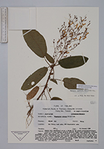
| Family | Acanthaceae |
| Identification | Staurogyne obtusa (Nees) O. K. |
| Determined by | Bertel Hansen |
| Identification qualifier | |
| Field notes | Stems light greenish, inflorescence purplish; corolla tube: narrow part whitish-tan, expanded part and lobes white; midlobe of lower lip with a violet central blot inside, sidelobes faintly violet inside; anthers green above, pale light greenish-greyish underneath. |
| |
| This record has no coordinates. Display map with the 2 georeferenced records of Staurogyne obtusa in the AAU Herbarium Database. |
| New Search Modify Search |