AAU Herbarium Database |
| New Search Modify Search |
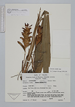
| Collector | Maxwell, J.F. |
| Number | 88-776 |
| Collected with | |
| Country | Thailand |
| Subpart | Chiang Mai |
| County | |
| Locality | Doi Sutep, east side, Kohntatahn Falls area. Presently partly shaded places in the deciduous dipterocarp oak forest; granite bedrock. |
| Coordinates | |
| Minimum elevation (m) | 600 |
| Maximum elevation (m) | 600 |
| Start date | 1988/06/18 |
| End date | 1988/06/18 |
| Family | Zingiberaceae |
| Identification | Curcuma angustifolia Roxb. |
| Determined by | C.Maknoi |
| Identification qualifier | |
| Field notes | Peduncle and lower bracts green, top bracts dark maroon; leafy stems: lower sheath dark maroon, upper ones green; blades dark green above, light green underneath; rhizome tan outside, cream-whitish inside. |
| |
| This record has no coordinates. Display map with the 7 georeferenced records of Curcuma angustifolia in the AAU Herbarium Database. |
| New Search Modify Search |