AAU Herbarium Database |
| New Search Modify Search |
| Collector | Maxwell, J.F. |
| Number | 88-756 |
| Collected with | |
| Country | Thailand |
| Subpart | Chiang Mai |
| County | |
| Locality | Doi Sutep, east side, Ru-See Cave. Distr. Muang. shaded to partly open, often disturbed places in the primary evergreen forest; granite bedrock |
| Coordinates | |
| Minimum elevation (m) | 1125 |
| Maximum elevation (m) | 1125 |
| Start date | 1988/06/15 |
| End date | 1988/06/15 |
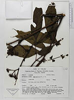
| Family | Leeaceae |
| Identification | Leea aequata L. |
| Determined by | Welzen P.C.v. |
| Identification qualifier | |
| Field notes | Shrub, less often a treelet, 2-2.5 m tall; inflorescence axes, calyx, petals outside light greenish; petals inside pale light-greenish/whitish; stamen tube white and turning light yelowish, anthers crea; fruits dull greenish; leaf segments dull dark green above, dull light greenish underneath |
| |
| This record has no coordinates. Display map with the 2 georeferenced records of Leea aequata in the AAU Herbarium Database. |
| New Search Modify Search |