AAU Herbarium Database |
| New Search Modify Search |
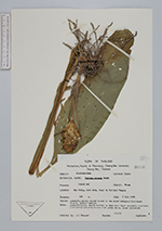
| Collector | Maxwell, J.F. |
| Number | 88-745 |
| Collected with | |
| Country | Thailand |
| Subpart | Chiang Mai |
| County | |
| Locality | Doi Sutep, east side. Trail to Pah Laht Temple. Muang District. Presently mostly shaded places in the mixed evergreen/deciduous forest, granite bedrock. |
| Coordinates | |
| Minimum elevation (m) | 550 |
| Maximum elevation (m) | 550 |
| Start date | 1988/06/09 |
| End date | 1988/06/09 |
| Family | Zingiberaceae |
| Identification | Curcuma ecomata Craib |
| Determined by | |
| Identification qualifier | |
| Field notes | Peduncle white; bracts whitish to very pale light greenish, sometimes pale whitish-violet; blades dark green above, green underneath. |
| |
| This record has no coordinates. Display map with the 1 georeferenced records of Curcuma ecomata in the AAU Herbarium Database. |
| New Search Modify Search |