AAU Herbarium Database |
| New Search Modify Search |
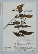
| Collector | Maxwell, J.F. |
| Number | 88-545 |
| Collected with | |
| Country | Thailand |
| Subpart | Chiang Mai |
| County | |
| Locality | Muang District. Doi Sutep, east side, above Pah Ngeub. Partly open place among granite rocks near the stream, more evergreen part of the deciduous dipterocarp-oak forest; granite bedrock |
| Coordinates | |
| Minimum elevation (m) | 600 |
| Maximum elevation (m) | 600 |
| Start date | 1988/04/28 |
| End date | 1988/04/28 |
| Family | Clusiaceae |
| Identification | Garcinia merguensis Wright |
| Determined by | C. Ngernsaengsaruay |
| Identification qualifier | |
| Field notes | Tree 10 m, dbh 13 cm; sap creamy; bark slightly roughened, brown; branchlets, pedicels, calyx, petal buds green; mature petals, filaments, pistillode dark red; anthers light yellowish; fragrant; blades dark green above, light green underneath. ♂ |
| |
| This record has no coordinates. Display map with the 16 georeferenced records of Garcinia merguensis in the AAU Herbarium Database. |
| New Search Modify Search |