AAU Herbarium Database |
| New Search Modify Search |
| Collector | Maxwell, J.F. |
| Number | 86-499 |
| Collected with | |
| Country | Thailand |
| Subpart | Phatthalung |
| County | |
| Locality | See Bahn Pote District. Kao Boo-Kao Yah National Park, Pa Peung area. Shaded area, primary evergreen forest; limestone bedrock. |
| Coordinates | |
| Minimum elevation (m) | 200 |
| Maximum elevation (m) | 200 |
| Start date | 1986/07/26 |
| End date | 1986/07/26 |
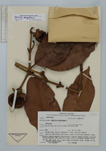
| Family | Clusiaceae |
| Identification | Garcinia mangostana L. |
| Determined by | C. Ngernsaengsaruay |
| Identification qualifier | |
| Field notes | Tree 8 m, dbh 20 cm; bark scaly, brown; sap yellow; peduncles green; fruiting seaple greenish with brownish margins; fruits slightly immature, yellow-greenish with pale yellow sap, 4.5-5 cm diameter; stigma brown; blades dark green above, light green underneath; often planted for the fruits (edible aril). N.V.: mahn koot |

| |
| This record has no coordinates. Display map with the 3 georeferenced records of Garcinia mangostana in the AAU Herbarium Database. |
| New Search Modify Search |