AAU Herbarium Database |
| New Search Modify Search |
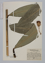
| Collector | Maxwell, J.F. |
| Number | 78-301 |
| Collected with | |
| Country | Malaysia |
| Subpart | Selangor |
| County | |
| Locality | genting Highlands, 16 th mile at Ulu Gombak; shaded evergreen forest near the river. |
| Coordinates | |
| Minimum elevation (m) | 325 |
| Maximum elevation (m) | 325 |
| Start date | 1978/06/03 |
| End date | 1978/06/03 |
| Family | Zingiberaceae |
| Identification | Amomum uliginosum J.Koenig |
| Determined by | |
| Identification qualifier | |
| Field notes | Leaf stems 2 m with 18-22 leaves, lowest 2-3 very reduced; bracts brown, anther, staminoides, ventral side filament white; dorsal side filament pink. Fruit red. |
| |
| This record has no coordinates. Display map with the 4 georeferenced records of Amomum uliginosum in the AAU Herbarium Database. |
| New Search Modify Search |