AAU Herbarium Database |
| New Search Modify Search |
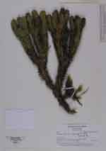
| Collector | Madsen, J. E. |
| Number | 8569 |
| Collected with | Carlos Chimbo |
| Country | Ecuador |
| Subpart | LOJA |
| County | |
| Locality | Rd. Yangana - Cerro Toledo, km 21. Paramo and chapparal. |
| Coordinates | 4° 24' 8'' S 79° 6' 40'' W |
| Minimum elevation (m) | 3400 |
| Maximum elevation (m) | 3400 |
| Start date | 2001/10/18 |
| End date | 2001/10/18 |
| Family | Lycopodiaceae |
| Identification | Huperzia kuesteri (Nessel)B. Øllg. |
| Determined by | B.Ollgaard |
| Identification qualifier | |
| Field notes | Terrestrial, forming 40-60 cm wide clumps. Stems erect. |
| |
 Other records of Huperzia kuesteri Other records of Huperzia kuesteriThe map displays only records from the Aarhus Herbarium Database. The records may not represent the full distribution of Huperzia kuesteri |
| New Search Modify Search |