AAU Herbarium Database |
| New Search Modify Search |
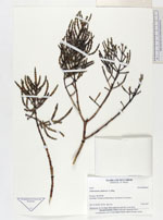
| Type of: | Mangleticornia ecuadorensis P.W.Ball, X.Cornejo & G.Kadereit |
| Collector | Madsen, J. E. |
| Number | 63972 |
| Collected with | |
| Country | Ecuador |
| Subpart | GUAYAS |
| County | |
| Locality | Isla Punà. Vicinity of Punà Nueva. Disturbed salt marshes. |
| Coordinates | 2° 44' S 79° 55' W |
| Minimum elevation (m) | 0 |
| Maximum elevation (m) | 0 |
| Start date | 1987/10/01 |
| End date | 1987/10/01 |
| Family | Amaranthaceae |
| Identification | Mangleticornia ecuadorensis P.W.Ball, X.Cornejo & G.Kadereit |
| Determined by | G.Kadereit |
| Identification qualifier | |
| Field notes | Herbaceous, to 2 m high. Stem-segments typically 4 mm thick. |
| |
 Other records of Mangleticornia ecuadorensis Other records of Mangleticornia ecuadorensisThe map displays only records from the Aarhus Herbarium Database. The records may not represent the full distribution of Mangleticornia ecuadorensis |
| New Search Modify Search |