AAU Herbarium Database |
| New Search Modify Search |
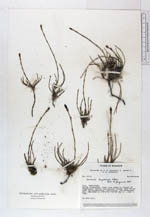
| Collector | Lawesson, J. E. |
| Number | 44131 |
| Collected with | Thomas Laessoe & Peter Moller Jorgensen |
| Country | Ecuador |
| Subpart | TUNGURAHUA |
| County | |
| Locality | Volcán Tungurahua. Trail from Baños to refugio of Tungurahua. Pasture and mountain forest with many Ericaceae, Melastomataceae, Orchidaceae, and Asteraceae. |
| Coordinates | 1° 27' S 78° 27' W |
| Minimum elevation (m) | 2000 |
| Maximum elevation (m) | 3800 |
| Start date | 1983/05/31 |
| End date | 1983/06/01 |
| Family | Equisetaceae |
| Identification | Equisetum bogotense Kunth |
| Determined by | B. Ollgaard, 1984 |
| Identification qualifier | |
| Field notes | On open soil. |
| |
| Display all 71 georeferenced records of Equisetum Equisetum bogotense |
| New Search Modify Search |