AAU Herbarium Database |
| New Search Modify Search |
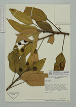
| Collector | Solomon, J.C. |
| Number | 15373 |
| Collected with | |
| Country | Bolivia |
| Subpart | La Paz |
| County | |
| Locality | Prov. Sud. Yungas. 1.4 km W of Unduavi, on new road between Chuspidata and La Paz. Low cloud forest at the upper limit of forest vegetation; most common tree genera: Miconia, Orepanax, Vallea and Clethra. |
| Coordinates | 16° 18' S 67° 55' W |
| Minimum elevation (m) | 3400 |
| Maximum elevation (m) | 3400 |
| Start date | 1986/07/02 |
| End date | 1986/07/02 |
| Family | Araliaceae |
| Identification | Oreopanax rusbyi Britton |
| Determined by | F.Borchsenius |
| Identification qualifier | |
| Field notes | Shrub 2.5 m. |
| |
 Other records of Oreopanax rusbyi Other records of Oreopanax rusbyiThe map displays only records from the Aarhus Herbarium Database. The records may not represent the full distribution of Oreopanax rusbyi |
| New Search Modify Search |