AAU Herbarium Database |
| New Search Modify Search |
| Collector | Solomon, J.C. |
| Number | 11835 |
| Collected with | B.Stein, M.Uehling |
| Country | Bolivia |
| Subpart | La Paz |
| County | |
| Locality | Prov. Murillo. 27.4 km N (below) of the dam at Lago Zongo; Valle del Zongo. Moist cloud forest with some tree ferns. North facing slopes more disturbed, drier. |
| Coordinates | 16° 7' S 68° 7' W |
| Minimum elevation (m) | 2500 |
| Maximum elevation (m) | 2500 |
| Start date | 1984/03/16 |
| End date | 1984/03/16 |
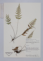
| Family | Aspleniaceae |
| Identification | Asplenium auritum Sw. |
| Determined by | H.v.d. Werff |
| Identification qualifier | |
| Field notes | Epiphytic fern. |
| |
| Display all 140 georeferenced records of Asplenium Asplenium auritum |
| New Search Modify Search |