AAU Herbarium Database |
| New Search Modify Search |
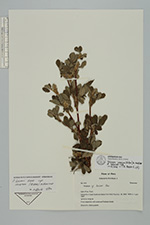
| Collector | Brandbyge, J. |
| Number | 573 |
| Collected with | |
| Country | Peru |
| Subpart | Puno |
| County | |
| Locality | Inticancha in lower Quebrada Metara N of Cerro Yaurinco. |
| Coordinates | 15° 10' S 70° 22' W |
| Minimum elevation (m) | 3850 |
| Maximum elevation (m) | 4000 |
| Start date | 1987/04/01 |
| End date | 1987/04/01 |
| Family | Rosaceae |
| Identification | Polylepis incarum (Bitter)M. Kessler & Schmidt-Leb. |
| Determined by | T.E. Boza E. |
| Identification qualifier | |
| Field notes | Puna vegetation with scattered Polylepis forest. Shrub 3 m. stem purplish. |
| |
 Other records of Polylepis incarum Other records of Polylepis incarumThe map displays only records from the Aarhus Herbarium Database. The records may not represent the full distribution of Polylepis incarum |
| New Search Modify Search |