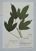
| Collector | Brandbyge, J. |
| Number | 42838 |
| Collected with | |
| Country | Ecuador |
| Subpart | COTOPAXI |
| County | |
| Locality | On the road from Latacunga to Quevedo. About 16 km W of Zumbahua. Upper andean forest, somewhat disturbed with dense Chusqua thickets. |
| Coordinates | 0° 57' S 78° 55' W |
| Minimum elevation (m) | 3400 |
| Maximum elevation (m) | 3400 |
| Start date | 1984/11/03 |
| End date | 1984/11/03 |
| Family | Araliaceae |
| Identification | Oreopanax avicenniifolius (Kunth)Decne. & Planch. |
| Determined by | Borchsenius, F. (AAU), 1997. |
| Identification qualifier | |
| Field notes | Small tree 4 m high, with short trunk and dense ramification. |
|
 Other records of Oreopanax avicenniifolius