AAU Herbarium Database |
| New Search Modify Search |
| Collector | Brandbyge, J. |
| Number | 42713 |
| Collected with | |
| Country | Ecuador |
| Subpart | TUNGURAHUA |
| County | |
| Locality | Quebrado Masavacho. Remnants of disturbed Ceja andina. |
| Coordinates | 1° 18' S 78° 35' W |
| Minimum elevation (m) | 3300 |
| Maximum elevation (m) | 3300 |
| Start date | 1984/09/19 |
| End date | 1984/09/19 |
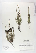
| Family | Equisetaceae |
| Identification | Equisetum bogotense Kunth |
| Determined by | B. Ollgaard, 1986 |
| Identification qualifier | |
| Field notes | Common name: "Caballo chupa". |
| |
| Display all 71 georeferenced records of Equisetum Equisetum bogotense |
| New Search Modify Search |